[]
Your ongoing selection
Asset(s) Assets
Your quote 0

Your selection

Clear selection
{"event":"pageview","page_type1":"catalog","page_type2":"image_page","language":"en","user_logged":"false","user_type":"ecommerce","nl_subscriber":"false"}
{"event":"ecommerce_event","event_name":"view_item","event_category":"browse_catalog","ecommerce":{"items":[{"item_id":"BL3304481","item_brand":"other","item_category":"illustration","item_category2":"out_of_copyright","item_category3":"standard","item_category5":"not_balown","item_list_name":"search_results","item_name":"chart_and_drawings_of_easter_island","item_variant":"undefined"}]}}
Metadata Block (Hidden)

Contact us for further help

High res file dimension

Search for more high res images or videos

Chart and drawings of Easter island.

IMAGE number
BL3304481
Image title
Chart and drawings of Easter island.
Auto-translated text View Original Source
Location
British Library, London, UK
Image description

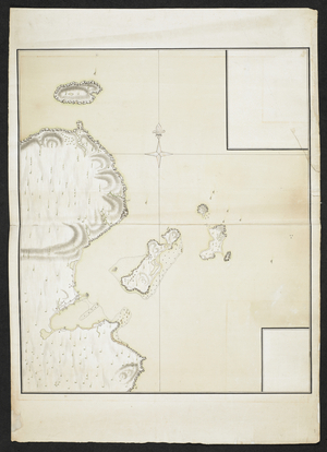
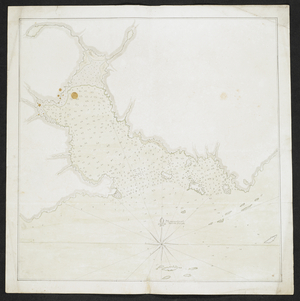
SIXTY-SEVEN Charts and maps illustrating the voyages and surveys of Capt. James Cook, R.N, and other discoverers; circ. 1760- 1780. Author: Cook, Captain James / c 1760-1780 Source/Shelfmark: Add. 31360, no.34

Photo credit
From the British Library archive / Bridgeman Images
Image keywords
cartography / archipelago / islands / 18th century / chart / cartographic
Leave the work to our dedicated Account Managers
License details
Your details
*
*
*
*
*
Asset - General information
Copyright status
No Additional Copyright
Permissions
More info
Permission required for non-editorial use (inc book and magazine covers). Please contact us
Largest available format 6112 × 8383 px 29 MB
Dimension [pixels] Dimension in 300dpi [mm] File size [MB]
Large 6112 × 8383 px 517 × 710 mm 28.8 MB
Medium 747 × 1024 px 63 × 87 mm 894 KB

Similar Images